

Related:
 A Vortex IPA at Knotty Pine Bar & Grill – 201 E Dock St. Westport
A friendly place to stop in for a beer.
Related:
 Maritime culture and an active seaport.
 The Cove – A beach made of coarse sand and pebbles.
Below: A very nice image identifying local coastal features.
Source/credit: City of Westport


 Heading Out

 When the time is right, the top of Mount Rainier is visible from this cam:
Westport – coastal weather cam here.
Related:
 Westport
 Westport


 When the time is right, the top of Mount Rainier is visible from this cam:
Westport – coastal weather cam here.
Related:

 When the time is right, the top of Mount Rainier is visible from this cam:
Westport – coastal weather cam here.
Related:


 When the time is right, the top of Mount Rainier is visible from this cam:
Westport – coastal weather cam here.
Related:
 Westport – August 30th
Friendly people, good weather and a large number of cars and spectators on site.
Local group info here.


 When the time is right, the top of Mount Rainier is visible from this cam:
Westport – coastal weather cam here.
Related:
 Image above: Sign seen at Westport, WA on Aug 30, 2025.
This sign is posted NE of the viewing tower between the road and the jetty.
This area is identified as The Groins in the image below:
Source/credit: City of Westport
Any similar sign at Penn Cove?
Any questions from newspeople?
Penn Cove
Below:
I found the sign below posted near the boat launch at Captain Thomas Coupe Park on 4/2/2020.
 Image below:
This sign was seen posted near the boat ramp on my 4/2/2020 site visit to Monroe Landing.
Previous site visit here.

Penn Cove status on Aug 31, 2025:
Coupeville
“Clams, mussels and oysters CLOSED year-round.”
“…clams, oysters, and mussels from this beach are not fit for human consumption at any time.”
“This beach is within the closure area for a sewage treatment plant outfall and is unsafe for recreational shellfish harvesting.”
Source: WDFW
North side of Penn Cove at Monroe Landing
“Clams, mussels and oysters CLOSED year-round.”
“This beach is within the closure area for a sewage treatment plant outfall and is unsafe for recreational shellfish harvesting.”
Source: WDFW
More Here
Below: An April 6, 2020 audio file describing recreational shellfish harvest and sewage treatment outfall at Penn Cove.
Has anything changed?
Newspeople remain silent.
12:44 audio file and local photos of Penn Cove:
Podcast 4 Another Month With An R – Whidbey Sewage Treatment Plant Outfalls
A photo tour of Penn Cove:
Wastewater Treatment Plant – Department of Ecology Award For Outstanding Performance
Possibly of interest:
Federal Failure At Damon Point
Sound Publishing And Black Press Media
 Westport
When the time is right, the top of Mount Rainier is visible from this cam:
Westport – coastal weather cam here.
Related:
 Above: What we found after our climb to the top of the lighthouse.
The live cam now includes views from the tower near the marina and the Westport Maritime Museum.
A very powerful lens now delivers views from Grays Harbor Light.
When the time is right, the top of Mount Rainier is visible from the tower cam.
All 3 Westport coastal weather cams can be viewed here.
Westport is a great location for walking.
A photo tour here:
 Westport, WA is a pedestrian-friendly town with easy access to views of the working waterfront.
The Marina
 A genuine seaport town.


 Maritime culture just outside the marina:


Observation Tower
When you’re done at the marina, walk up to the public viewing tower and take a look:
 Detailed information on the tower is here.
The tower has a live web cam showing views in all directions.
A fixed cam at Westport Maritime Museum also shows a view of the marina.
Both cams can be seen here.
Below: A very nice image identifying local coastal features.
Source/credit: City of Westport
The Cove
The Westport Light Trail begins at the base of the observation tower and will take you to the cove.
Walk the cove towards the state park and look for views of an international maritime culture.
An early March 2025 view:
 At the state park, you may continue on the Westport Light Trail all the way south to W Ocean Ave. From there, it’s a short walk to the lighthouse. Google maps shows all of the trail here.
 Look for surfers at the jetty.

 Look for dog friendly beaches south of the jetty.

 Finish up the Westport Light Trail and climb to the top of the lighthouse.
 When you finish at the lighthouse you may head back to the beach on W Ocean Ave.

 Head south for more dog friendly beach and plenty of sand dollars.

 Stay overnight?
Two personal blogs:
Frank Hotels Westport – Good Experience – Again
These folks operate more than one location in town:
Frank Hotels web page is here.
 Image above: July 6th, 2024. Looking over the jetty that connects to Damon Point on the far end. We are near the end of the jetty adjacent to the Wastewater Treatment Plant. Click image once or twice to show detail.
Significant History
1916 – Jetty adjacent to the former public parking area at Damon Point is installed. Apparently, no maintenance has been done on this part of the jetty since 1916.
In The News
Coastal town erosion: Waves, sand, and human intervention
North Cove, Westport and Ocean Shores all battling the march of the Pacific Ocean
By Mike McClanahan TVW • June 4, 2025 Posted by Daily World
Love To See Newspeople Ask:
When and why was a decision made to turn away from maintaining the 1916 jetty adjacent to former public parking areas at Damon Point?
Is the jetty adjacent to Damon Point the only section of jetty in Grays Harbor that has gone without maintenance since it was installed?
What would Westport look like if efforts to maintain the coast were suspended?
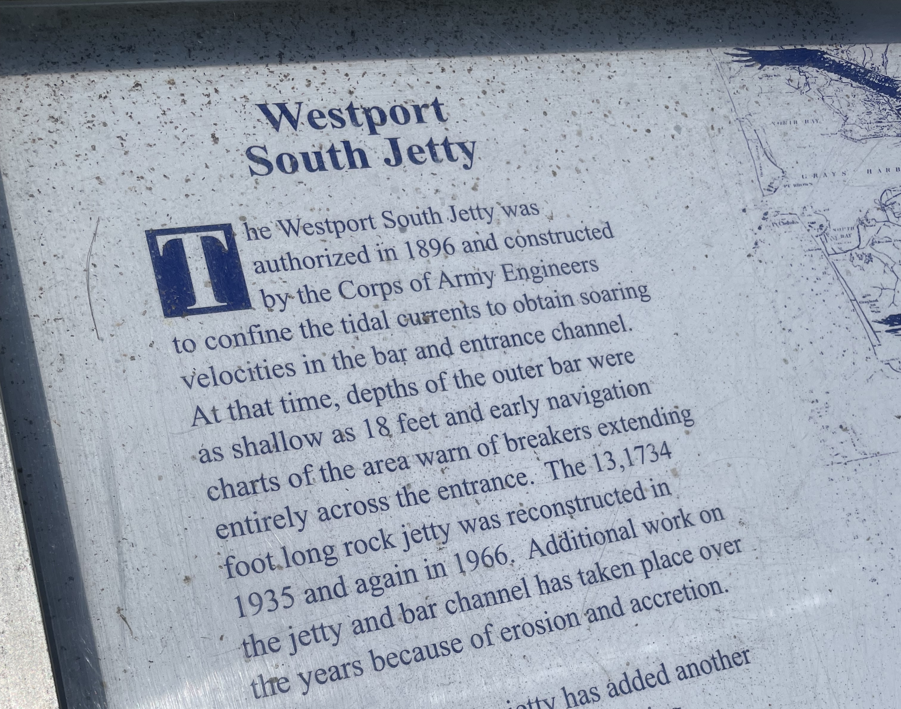 Above is a description of how the jetty on the Westport side has been maintained over the years.
Above: Posted near the Westport Light Trail.
Any similar plaque on the Ocean Shores side?
In the news:
Nov 2, 2023 The Daily World
A 100-year old jetty used to protect Ocean Shores. Can new technologies save its south end?
“In 1916, the U.S. Army Corps of Engineers completed the construction of Grays Harbor’s North Jetty, a three mile-long berm of boulders jutting into the Pacific, hugging and holding the entire southern shoreline of Ocean Shores. The body of water now known as Oyhut Bay did not exist.”
Grays Harbor did not encroach inland of the 1916 jetty at the time it was built?
1916 – Jetty adjacent to the former public parking area at Damon Point is installed. Apparently, no maintenance has been done on this part of the jetty since 1916.
If the jetty was a priority in 1916, why was it let go as the years went by?
Any federal money for ports and coastal improvement?
$6.3 million in federal cash for a used Ocean Shores hotel.
Any questions from newspeople?
December 8, 2022 The Daily World
Dept. of Ag invests $6.3M to purchase Ocean Shores hotel
$6.3 million “to fund the acquisition of an existing hotel. Marathon Enterprises Inc. is located in Ocean Shores, Grays Harbor County, Washington. The project is expected to result in saving eight jobs and creating one full time job.”
Zero questions from small or large newspapers. Zero questions from TV newspeople.
Information suppression protocols:
Here is a broken link that once announced Congressman Derek Kilmer’s success in pulling together $6.3 million in federal cash for the used Ocean Shores hotel. Why is this public information no longer available?
Other sources:
$6.3 million will be used to purchase an Ocean Shores hotel; saves jobs
KXRO News December 7, 2022
Love to see newspeople out asking questions.
What we get now is sort of a press release style of news reporting where a statement is prepared by whatever agency was involved in the latest policy update, drug bust/federal grant money award, etc.
Newspeople post this statement as is. A 5th grade book report would require more in the way of asking questions.
Ports and coastal improvement:
Oct. 9, 2020 U.S. Army Corps of Engineers Headquarters Website
About the U.S. Army Corps of Engineers
“One of the Seattle District’s primary missions is to maintain the navigation channels and harbors in the Pacific Northwest. Maintenance and navigation dredging is done frequently in harbor areas, ports and marinas. A significant component of Washington’s economy depends on navigation and commerce, which in turn depends on dredging navigation channels.”
No longer Here – Ferry to Westport – Fell Apart on the Ocean Shores Side
Ocean Shores to Westport: Remembering the El Matador Ferry
By Douglas Scott
“Separated by less than two miles as the crow flies, traveling between Westport and Ocean Shores should be a quick excursion, but the drive is an hour long between the two seaside towns.”
“Sadly, the ferry service shut down in 2008, but not due to lack of popularity. While the ferry service had seen closures in previous years, the service would always pick back up and be celebrated by residents and visitors alike. Sadly, after too much sand and silt built up around the Ocean Shores marina, the El Matador was forced to cancel trips across the harbor. What was once a family-friendly boating experience and adventure across the harbor is now relegated to fond memories.”
Different story over at Westport
“…less than two miles as the crow flies…”
Imagine telling the fishing boat captains over at Westport that their access to a 100 year old armor-plated harbor was going to be let go because too much sand and silt built up around the marina.
Love to see the press head over to Westport and give some credit where credit is due.
Did Westport ever score $6.3 million in federal cash for a used hotel?
Any questions from newspeople?
December 8, 2022 The Daily World
Dept. of Ag invests $6.3M to purchase Ocean Shores hotel
Visit Westport and take a look at a community that faces the same concerns Re: tsunami zone, global warming, sea level rise, climate crisis, king tides, coastal erosion, El Niño/La Niña, winter storms and did not let any of that get in the way of keeping things maintained on their working waterfront.
Related:
Feb, 2024 – 98569 Coastal Erosion Attitudes
Damon Point – A Race Against Nature?
Two Jetties – Westport and Damon Point
What would Westport look like?
Less Than Two Miles As The Crow Flies – Ocean Shores Marina History
Ocean Shores Marina History – A Time Gone By
Westport, WA Foot Ferry – A Race Against Nature?
Possibly of interest:
Sound Publishing And Black Press Media
 Westport
 Beaver wood.
 Happy Hours – Out and about with dogs in the PNW.
 Westport Jetty:


