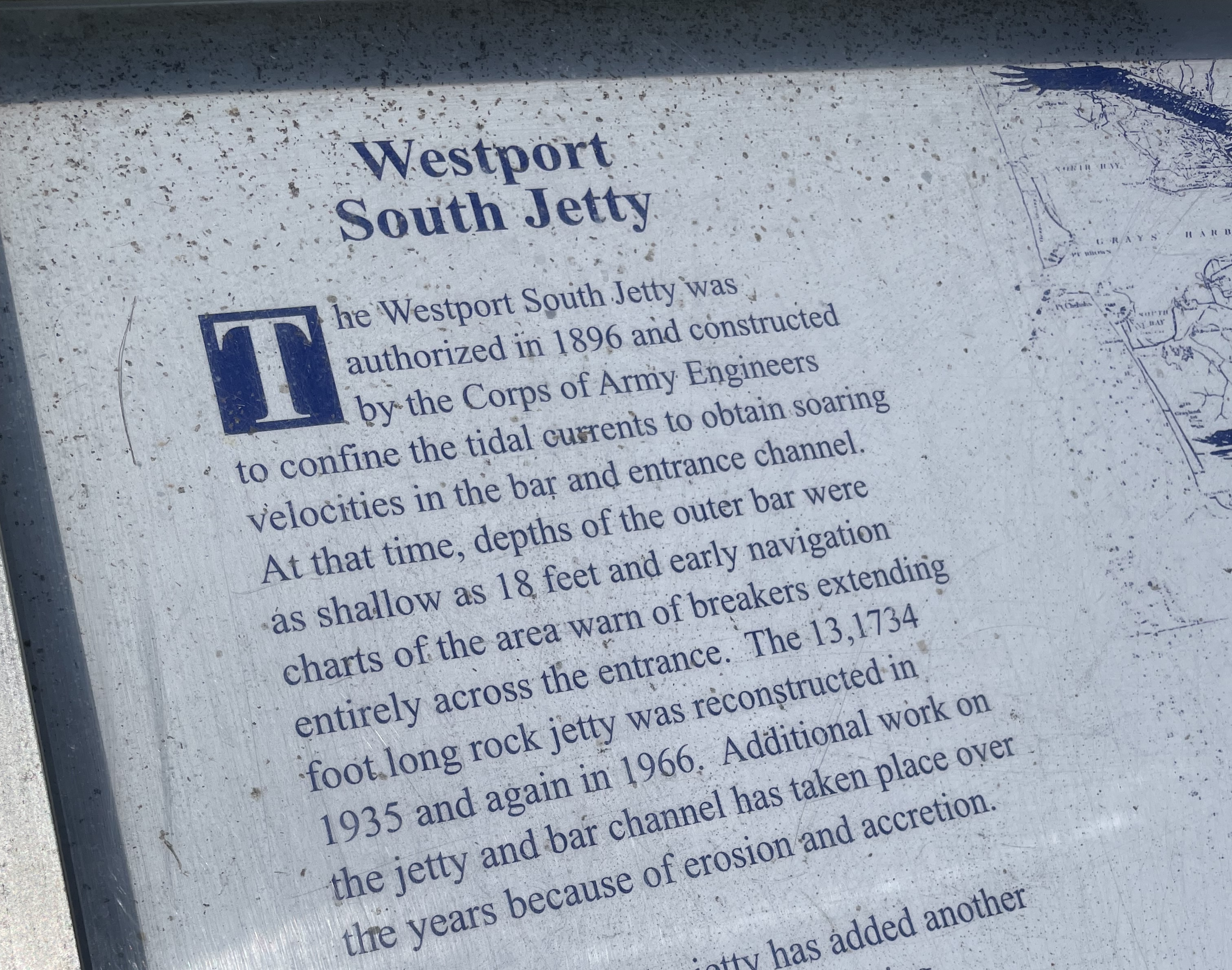
 Above is a description of how the jetty on the Westport side has been maintained over the years.
On the Ocean Shores side, the jetty adjacent to Damon Point appears to be neglected/not maintained over the years.
What would Westport look like if efforts to maintain the coast were suspended?
Above: Posted near the Westport Light Trail.
In The News
Foot ferry envisioned from Ocean Shores to Westport
Legislature pondering bill that would grant $50M for fast foot ferries throughout Washington waters
The Daily World – Feb 26, 2025
“A ferry from Ocean Shores to Westport and back was part of the discussion of a bill introduced by state Rep. Greg Nance, D-Bainbridge Island. Nance mentioned Grays Harbor and said the ferry ride between Westport and Ocean Shores could serve tourists and locals alike.”
“The idea hearkens back to a century ago when an armada of privately operated steamers offered the easiest way to travel among Puget Sound settlements. Washington State Ferries emerged from that legacy, but islanders and commuters say they urgently need an alternative to the agency’s iconic green-and-white car ferries, which have become unreliable.”
The folks who are unable to provide reliable Washington State Ferry service want to manage a grant program for foot ferries.
Any Interview With Representative Nance?
Any telephone interview? Any web based interviews? This is routine stuff in 2025.
Looks like the local press was unable to interview Representative Nance before this story was posted.
Questions that may have come up in the interview are in bold type below:
Representative Nance,
In 2008, the El Matador ferry was shut down:
“…too much sand and silt at the entrance and inside the Ocean Shores Marina, and no governmental entity is prepared to apply for dredging permits.”
Are you aware that the situation has now become worse?
The public parking areas adjacent to Damon Point are now closed. Beach walkers have no access to Damon Point.
City of Ocean Shores:
“Damon Point Area Access Closed to the Public – Beginning January 27, 2025
Beginning Monday at 7:00am, public access to Damon Point will be strictly prohibited. We will begin stockpiling cobble in the parking lot to the left of the easement. To ensure everyone’s safety access to the area will be closed. This is a critical operation, and we appreciate your full cooperation.”
This public parking area is adjacent to where the El Matador ferry landed on the Ocean Shores side back in 2008.
Representative Nance,
What port facility on the Ocean Shores side would be suitable for the new ferry landing? When is the last time you toured this area? When is the last time you met with Ocean Shores political leaders?
Representative Nance,
Have you been over to Westport to look at a community that faces the same concerns Re: tsunami zone, global warming, sea level rise, climate crisis, king tides, coastal erosion, El Niño/La Niña, winter storms and did not let any of that get in the way of keeping things maintained on their working waterfront?
Representative Nance,
When and why was a decision made to turn away from maintaining the 1916 jetty adjacent to public parking areas at Damon Point?
Representative Nance,
Were you aware that $6.3 million in federal cash went for a used Ocean Shores hotel in late 2022?
Were Washington State lawmakers consulted prior to this deal going through?
December 8, 2022 The Daily World
Dept. of Ag invests $6.3M to purchase Ocean Shores hotel
$6.3 million “to fund the acquisition of an existing hotel. Marathon Enterprises Inc. is located in Ocean Shores, Grays Harbor County, Washington. The project is expected to result in saving eight jobs and creating one full time job.”
Zero questions from small or large newspapers. Zero questions from TV newspeople.
Other sources:
$6.3 million will be used to purchase an Ocean Shores hotel; saves jobs
KXRO News December 7, 2022
Love to see newspeople out asking questions.
What we get now is sort of a press release style of news reporting where a statement is prepared by whatever agency was involved in the latest policy update, drug bust/federal grant money award, etc.
Newspeople post this statement as is. A 5th grade book report would require more in the way of asking questions.
In the news:
A $50M idea to add lots of foot ferries to WA waters — fast
Feb 24, 2025 – The Seattle Times
Seattle Times allows comments.
Many comments have been posted with the article above.
Possibly of Interest
At Damon Point, Ocean Shores once had an active marina with a restaurant, cocktail lounge and salmon charter boat outings. The Silver King Motel was there too.
Damon Point was once a state park. When and why did Washington State Parks let it go?
Ocean Shores Marina History – A Time Gone By
1916 – Jetty adjacent to the public parking area at Damon Point is installed. Apparently, no maintenance has been done on this part of the jetty since 1916. If the jetty was a priority in 1916, why was it let go as the years went by?
At Damon Point, the Ocean Shores side once had a ferry to Westport. People liked it. It was shut down because:
“…too much sand and silt built up around the Ocean Shores marina, the El Matador was forced to cancel trips across the harbor.”
Different story over at Westport
“…less than two miles as the crow flies…”
Imagine telling the fishing boat captains over at Westport that their access to a 100 year old armor-plated harbor was going to be let go because too much sand and silt built up around the marina.
Related:
Feb, 2024 – 98569 Coastal Erosion Attitudes
Damon Point – A Race Against Nature?
Damon Point Beach Access
Erosion Crisis 98569? – Random Thoughts
Two Jetties – Westport and Damon Point
Imagine telling the fishing boat captains over at Westport that their access to a 100 year old armor-plated harbor was going to be let go
Westport, WA Foot Ferry – A Race Against Nature?
1916 Jetty – Damon Point
Coastal Erosion Attitudes – 98569
What would Westport look like?
Damon Point – Coastal Erosion Attitudes
Less Than Two Miles As The Crow Flies – Ocean Shores Marina History
98569 Coastal Erosion Attitudes
Room For Improvement – 98569
Federal Cash For The Coast – 98569
Possibly of interest:
Sound Publishing And Black Press Media
 Above: years ago- taking a look at maritime culture. Port Townsend boatyard.


