Above: July 6th, 2024. Looking over the jetty that connects to Damon Point on the far end. We are near the end of the jetty adjacent to the Wastewater Treatment Plant.
Zero questions from small or large newspapers. Zero questions from TV newspeople.
Drive down to the former public parking area at Damon Point and see what Westport would look like today if efforts to maintain the coast were suspended decades ago.
The barricades at Damon Point have been removed, however Damon Point remains closed to public access by the Washington State Department of Natural Resources.
Additionally, many of the beaches surrounding Damon Point are privately owned. The city of Ocean Shores asks that you respect property boundaries when visiting the area.”
Above: July 6th, 2024. Looking over the jetty that connects to Damon Point on the far end. We are near the end of the jetty adjacent to the Wastewater Treatment Plant. Click image once or twice to show detail.
“Meanwhile, Damon Point has been closed for more than a year due to dangerous conditions, and the nearby Quinault RV Park and Marina have been closed indefinitely since last May due to storm damage. The U.S. Army Corps of Engineers completed construction of the North Jetty, a three mile-long berm of boulders jutting into the Pacific, in 1916.”
Ocean Shores City Administrator Scott Andersen:
“What we’d really love to see is the remnant jetty also rebuilt as part of that process. That would help us save a lot of land down there. That right now is not on their radar, they view this as a navigation channel issue and that’s why the Port is playing such a big role in their decision-making on this.”
“We were hoping this would happen two years ago, it’s been delayed like a lot of federal projects, but we’re glad it’s finally getting done.”
Our Take
“…delayed like a lot of federal projects…”
Plenty of US federal cash for foreign governments and their military related projects in recent years. Less priority here at home.
Drive down to the former public parking area at Damon Point and see what Westport would look like today if efforts to maintain the coast were suspended decades ago.
Zero Questions From Newspeople:
When and why was a decision made to turn away from maintaining the 1916 jetty adjacent to former public parking areas at Damon Point?
Is the jetty adjacent to Damon Point the only section of jetty in Grays Harbor that has gone without maintenance since 1916?
What would Westport look like if efforts to maintain the coast were suspended?
Funding Priorities
In recent years, the US federal government has prioritized big cash for Ukraine, bombing the Middle East and conducting airstrikes on Somalia and elsewhere. The big mystery is the $6.3 million for the used Ocean Shores hotel. Seems like leaders from all layers of government would have been interested in this story and that local people and the general public would have wanted to be informed on how all this came together. Newspeople would not have needed to travel to foreign lands to interview all the players involved.
Today’s American culture is truly weak in terms of newspeople asking questions.
Welcome Home Troops
Local Oddities
In the news:
$6.3 million in federal cash for a used Ocean Shores hotel.
Above: Aug 9, 2025. We are looking across the entrance to Grays Harbor from Oyhut Wildlife Recreation Area. Westport Jetty is in the distance. The failed 1916 jetty is seen closer to shore. The crumbling jetty is a happy summer spot for pelicans and runs from the water treatment plant to the old marina site at Ocean Shores.
Below: July 6th, 2024. Looking over the jetty that connects to Damon Point on the far end. We are near the end of the jetty adjacent to the Wastewater Treatment Plant. Click image once or twice to show detail.
Zero questions from small or large newspapers. Zero questions from TV newspeople.
Drive down to the former public parking area at Damon Point and see what Westport would look like today if efforts to maintain the coast were suspended decades ago.
Zero Questions From Newspeople:
When and why was a decision made to turn away from maintaining the 1916 jetty adjacent to former public parking areas at Damon Point?
Is the jetty adjacent to Damon Point the only section of jetty in Grays Harbor that has gone without maintenance since it was first installed?
What would Westport look like if efforts to maintain the coast were suspended?
Funding Priorities
In recent years, the federal government has prioritized big cash for Ukraine, bombing the Middle East and conducting airstrikes on Somalia. The big mystery is the $6.3 million for the used Ocean Shores hotel. Seems like leaders from all layers of government would have been interested in this story and that local people and the general public would have wanted to be informed on how all this came together. Newspeople would not have needed to travel to foreign lands to interview all the players involved.
Today’s American culture is truly weak in terms of newspeople asking questions.
Image above: July 6th, 2024. Looking over the jetty that connects to Damon Point on the far end. We are near the end of the jetty adjacent to the Wastewater Treatment Plant. Click image once or twice to show detail.
Significant History
1916 – Jetty adjacent to the former public parking area at Damon Point is installed. Apparently, no maintenance has been done on this part of the jetty since 1916.
Grays Harbor did not encroach inland of the 1916 jetty at the time it was built?
1916 – Jetty adjacent to the former public parking area at Damon Point is installed. Apparently, no maintenance has been done on this part of the jetty since 1916.
If the jetty was a priority in 1916, why was it let go as the years went by?
Any federal money for ports and coastal improvement?
$6.3 million in federal cash for a used Ocean Shores hotel.
Zero questions from small or large newspapers. Zero questions from TV newspeople.
Information suppression protocols:
Here is a broken link that once announced Congressman Derek Kilmer’s success in pulling together $6.3 million in federal cash for the used Ocean Shores hotel. Why is this public information no longer available?
What we get now is sort of a press release style of news reporting where a statement is prepared by whatever agency was involved in the latest policy update, drug bust/federal grant money award, etc.
Newspeople post this statement as is. A 5th grade book report would require more in the way of asking questions.
Visit Westport and take a look at a community that faces the same concerns Re: tsunami zone, global warming, sea level rise, climate crisis, king tides, coastal erosion, El Niño/La Niña, winter storms and did not let any of that get in the way of keeping things maintained on their working waterfront.
I was surprised to see (two years ago) many cheerful web pages describing good times for beach walkers out at Damon Point. It seemed tricky to find posts describing deteriorated conditions.
Various web pages would refer to the area as a state park.
It looks like the area is gone for good now. Love to see real newspeople take a hard look at what happened out here. When and why was a decision made to turn away from maintaining the 1916 jetty?
This public parking area is adjacent to where the El Matador ferry landed on the Ocean Shores side back in 2008.
Representative Nance,
What port facility on the Ocean Shores side would be suitable for the new ferry landing? When is the last time you toured this area? When is the last time you met with Ocean Shores political leaders?
Representative Nance,
Have you been over to Westport to look at a community that faces the same concerns Re: tsunami zone, global warming, sea level rise, climate crisis, king tides, coastal erosion, El Niño/La Niña, winter storms and did not let any of that get in the way of keeping things maintained on their working waterfront?
Representative Nance,
When and why was a decision made to turn away from maintaining the 1916 jetty adjacent to public parking areas at Damon Point?
Representative Nance,
Were you aware that $6.3 million in federal cash went for a used Ocean Shores hotel in late 2022?
Were Washington State lawmakers consulted prior to this deal going through?
What we get now is sort of a press release style of news reporting where a statement is prepared by whatever agency was involved in the latest policy update, drug bust/federal grant money award, etc.
Newspeople post this statement as is. A 5th grade book report would require more in the way of asking questions.
Many comments have been posted with the article above.
Possibly of Interest
At Damon Point, Ocean Shores once had an active marina with a restaurant, cocktail lounge and salmon charter boat outings. The Silver King Motel was there too.
1916 – Jetty adjacent to the public parking area at Damon Point is installed. Apparently, no maintenance has been done on this part of the jetty since 1916. If the jetty was a priority in 1916, why was it let go as the years went by?
At Damon Point, the Ocean Shores side once had a ferry to Westport. People liked it. It was shut down because:
Image above: Taken on July 6th, 2024 from the public access trail adjacent to the Ocean Shores Wastewater Treatment Plant.
Priorities are in place (as they should be) and so is this armor-plated bulkhead.
Was any priority established for maintaining the Damon Point/Ocean Shores Marina end of the jetty?
When I started blogging about Damon Point beach access two years ago, I thought improvements would happen at some point.
I was surprised to see (two years ago) many cheerful web pages describing good times for beach walkers out at Damon Point. It seemed tricky to find posts describing deteriorated conditions.
Various web pages would refer to the area as a state park.
With Sadness
It looks like the area is gone for good now. Love to see real newspeople take a hard look at what happened out here. When and why was a decision made to turn away from maintaining the 1916 jetty?
Significant History
At Damon Point, Ocean Shores once had an active marina with a restaurant, cocktail lounge and salmon charter boat outings. The Silver King Motel was there too.
1916 – Jetty adjacent to the public parking area at Damon Point is installed. Apparently, no maintenance has been done on this part of the jetty since 1916. If the jetty was a priority in 1916, why was it let go as the years went by?
At Damon Point, the Ocean Shores side once had a ferry to Westport. People liked it. It was shut down because:
Zero questions from small or large newspapers. Zero questions from TV newspeople.
Information suppression protocols: Here is a broken link that once announced Congressman Derek Kilmer’s success in pulling together $6.3 million in federal cash for the used Ocean Shores hotel. Why is this public information no longer available?
What we get now is sort of a press release style of news reporting where a statement is prepared by whatever agency was involved in the latest policy update, drug bust/federal grant money award, etc.
Newspeople post this statement as is. A 5th grade book report would require more in the way of asking questions.
Something tells me the newspeople below have never walked the Ocean Shores beaches from State Route 115/Lighthouse Suites Inn south to North Jetty, Damon Point loop and all of the beach between the Ocean Shores Wastewater Treatment Plant and the old marina.
Did they head over to Westport and take a look at a community that faces the same concerns Re: tsunami zone, global warming, sea level rise, climate crisis, king tides, coastal erosion, El Niño/La Niña, winter storms and did not let any of that get in the way of keeping things maintained on their working waterfront?
On the Ocean Shores side, the jetty adjacent to Damon Point appears to be neglected/not maintained over the years.
What would Westport look like if efforts to maintain the coast were suspended?
Blogged about it two years ago:
Today, beach walkers moving toward the water from the parking area at Damon Point are channeled to a choice between an eroded/unsafe former road drop-off and private property that is posted, telling walkers that they are not welcome. WTF?
KOSW, this morning discussed some erosion issues at Damon Point.
I will try to find a link with the interview to post later.
“We’re either going to succeed or we’re going to fail big.”
By Jenny Allison – The Cool Down October 17, 2024
“The Cool Down is mainstream America’s guide to the cleaner, cooler future, helping a monthly audience of 30M+ people make better choices for themselves and the planet.”
Zero questions from small or large newspapers. Zero questions from TV newspeople.
Significant History
At Damon Point, Ocean Shores once had an active marina with a restaurant, cocktail lounge and salmon charter boat outings. The Silver King Motel was there too.
1916 – Jetty adjacent to the public parking area at Damon Point is installed. Apparently, no maintenance has been done on this part of the jetty since 1916.
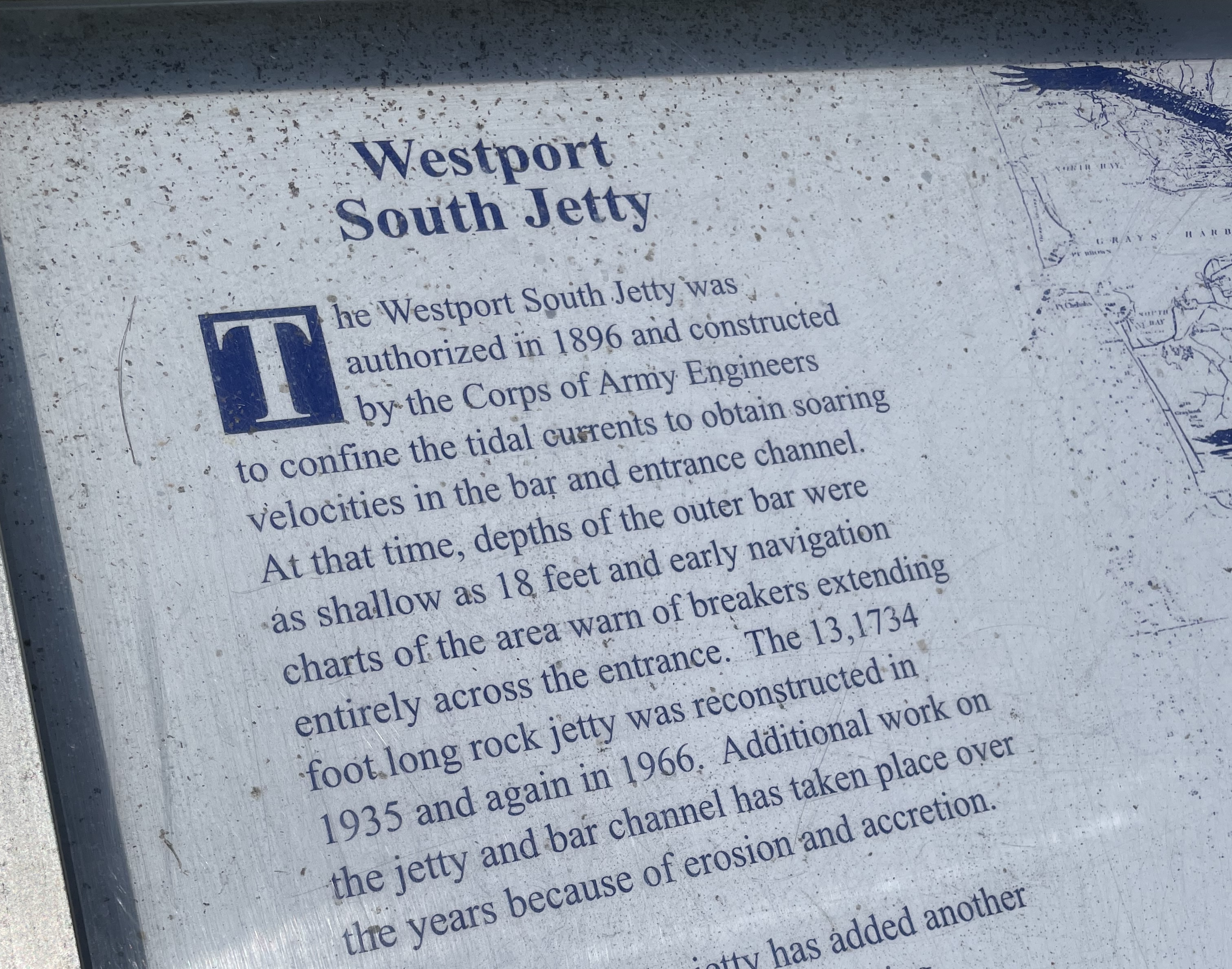
Concerns Re: tsunami zone, global warming, sea level rise, climate crisis, king tides, coastal erosion, El Niño/La Niña and winter storms or selling you stuff do not get in the way of keeping things maintained on the working waterfront at Westport. Well done.
Above: Posted near the Westport Light Trail, a description of how the jetty on the Westport side has been maintained over the years.
Love to see newspeople ask:
What would Westport look like if efforts to maintain the coast were suspended?
Above: I can’t show a recent photo of the foot ferry, because it no longer exists. We walked the Damon Point loop in June, and this was our view looking over to Westport.
Race against nature, but the original jetty adjacent to public parking at Damon Point has not been maintained in 108 years? Love to see newspeople ask questions on this.
Foot Ferry History
No longer Here – Ferry to Westport – Fell Apart on the Ocean Shores side back in 2008:
Zero questions from small or large newspapers. Zero questions from TV newspeople.
At Damon Point, Ocean Shores once had an active marina with a restaurant, cocktail lounge and salmon charter boat outings. The Silver King Motel was there too.
Image above: July 6th, 2024. Looking over the jetty that connects to Damon Point on the far end. We are near the end of the jetty adjacent to the Wastewater Treatment Plant.
Jetty Adjacent to Damon Point
The jetty adjacent to Damon Point appears to be neglected/not maintained over the years. Anyone going down there to walk at Damon Point will see this. The public beach access needs improvement.
Today, beach walkers moving toward the water from the parking area at Damon Point are channeled to a choice between an eroded/unsafe former road drop-off and private property that is posted, telling walkers that they are not welcome.
Image above: Taken on July 6th, 2024 from the public access trail adjacent to the Ocean Shores Wastewater Treatment Plant.
Priorities are in place (as they should be) and so is this armor-plated bulkhead.
1916 – Jetty adjacent to the public parking area at Damon Point is installed. Apparently, no maintenance has been done on this part of the jetty since 1916.
Race against nature, but the original jetty adjacent to public parking at Damon Point has not been maintained in 108 years? Love to see newspeople ask questions on this.
State Park
At some time in the past, a WA State Park was located at Damon Point. This is no longer the case:
Photo above: Nov 12, 2023 – No mention of a State Park
Looks like WA DNR, at some time in the past, took over what once was Damon Point State Park.
At Damon Point, Ocean Shores once had an active marina with a restaurant, cocktail lounge and salmon charter boat outings. The Silver King Motel was there too.
Concerns Re: tsunami zone, global warming, sea level rise, climate crisis, king tides, coastal erosion, El Niño/La Niña and winter storms do not get in the way of keeping things maintained on the working waterfront at Westport. Well done.
Above: Posted near the Westport Light Trail, a description of how the jetty on the Westport side has been maintained over the years.
What would Westport look like if efforts to maintain the coast were suspended?
Is there an attitude related to climate change/sea level rise that is used as an excuse to back away from maintaining the shore?
Public access for beach walkers at Damon Point:
For a town that promotes visitors, tourism and good times at the beach, things are piss poor over at Damon Point.
Today, beach walkers moving toward the water from the parking area at Damon Point are channeled to a choice between an eroded/unsafe former road drop-off and private property that is posted, telling walkers that they are not welcome. WTF?
Other Parts of the Beach are Maintained Year Round
The black top ends and the sand is cleared out of the way on a routine basis. Concerns Re: tsunami zone, global warming, sea level rise, climate crisis, king tides, coastal erosion, El Niño/La Niña and winter storms do not get in the way of keeping things maintained between the blacktop and the beach. Thanks go out to the people who do this work. We appreciate it.
Race against nature, but the original jetty adjacent to public parking at Damon Point has not been maintained in 108 years? Love to see newspeople ask questions on this.
Any federal money for ports and coastal improvement?
Plenty of cash for Ukraine/undeclared/unwon wars and here is what you get back home:
$6.3 million in federal cash for a used Ocean Shores hotel.
Concerns Re: tsunami zone, global warming, sea level rise, climate crisis, king tides, coastal erosion, El Niño/La Niña and winter storms do not get in the way of keeping things maintained on the working waterfront at Westport. Well done.
Above: Posted near the Westport Light Trail, a description of how the jetty on the Westport side has been maintained over the years.
What would Westport look like if efforts to maintain the coast were suspended?
Damon Point once had:
A state park.
Suitable public access for beach walkers.
At Damon Point, the Ocean Shores side once had an active marina with a restaurant, cocktail lounge and salmon charter boat outings. The Silver King Motel was there too.
At Damon Point, the Ocean Shores side once had a ferry to Westport. People liked it. It was shut down because:
Man made structures/one or more jetties installed at the entrance to Grays Harbor have altered the natural migration of sand, not coastal erosion/climate crisis/sea level rise?
“Another important partner, Martin said, will be the Quinault Indian Nation, which owns the Quinault Marina and RV Park on the east side of the bay.”
“Are we dealing with a natural process? Are we dealing with a partly man made process? Or a combination of both?”
The article above has some excellent images, showing the original jetty and what has changed since the first image was taken in 1942.
Jetty Adjacent to Damon Point
The jetty adjacent to Damon Point appears to be neglected/not maintained over the years. This first got my attention when going down there to walk at Damon Point. The public beach access needs improvement.
Image above: July 6th, 2024. Looking over the jetty that connects to Damon Point on the far end. We are near the end of the jetty adjacent to the Wastewater Treatment Plant.
Image above: July 6th, 2024. Looking over the jetty that connects to Damon Point on the far end. We are near the end of the jetty adjacent to the Wastewater Treatment Plant.
The jetty adjacent to Damon Point appears to be neglected/not maintained over the years. This first got my attention when going down there to walk at Damon Point. The public beach access needs improvement.
Below: Public access for beach walkers at Damon Point.
This local news article describes “coastal erosion” and “…rising sea levels due to climate change…” as part of the story.
Another local article below, tells us the jetty closest to the Damon Point parking area was installed in 1916.
Question for newspeople: What has been done to maintain the jetty since then?
Concerns Re: tsunami zone, global warming, sea level rise, climate crisis, king tides, coastal erosion, El Niño/La Niña and winter storms do not get in the way of keeping things maintained on the working waterfront at Westport. Well done.
Above: Posted near the Westport Light Trail, a description of how the jetty on the Westport side has been maintained over the years.
What would Westport look like if efforts to maintain the coast were suspended?
Damon Point once had:
A state park.
Suitable public access for beach walkers.
At Damon Point, the Ocean shores side once had an active marina with a restaurant, cocktail lounge and salmon charter boat outings. The Silver King Motel was there too.
At Damon Point, the Ocean Shores side once had a ferry to Westport. People liked it. It was shut down because:
Above: Posted near the Westport Light Trail, a description of how the jetty on the Westport side has been maintained over the years.
Below: Public access for beach walkers at Damon Point.
What would Westport look like if efforts to maintain the coast were suspended?
Damon Point once had:
A state park.
Suitable public access for beach walkers.
At Damon Point, the Ocean shores side once had an active marina with a restaurant, cocktail lounge and salmon charter boat outings. The Silver King Motel was there too.
At Damon Point, the Ocean Shores side once had a ferry to Westport. People liked it. It was shut down because:
The Ocean shores side once had an active marina with a restaurant, cocktail lounge and salmon charter boat outings. The Silver King Motel was there too.
The Ocean Shores side once had a ferry to Westport. People liked it. It was shut down because:
On the Ocean Shores side, the jetty adjacent to Damon Point appears to be neglected/not maintained over the years. This first got my attention when going down there to walk at Damon Point. The public beach access needs improvement.
This local news article describes “coastal erosion” and “…rising sea levels due to climate change…” as part of the story.
Another local article below, tells us the jetty closest to the Damon Point parking area was installed in 1916.
Question for newspeople: What has been done to maintain it since then?
Man made structures/one or more jetties installed at the entrance to Grays Harbor have altered the natural migration of sand, not coastal erosion/climate crisis/sea level rise?
US federal government is OK with doing maintenance in other areas:
Damon Point Beach Access
Beach access for people on foot cries out for improvement at Damon Point. If the city won’t improve it, maybe the tribe could charge a day use fee and let people walk across a safe path on their land to get to the beach?
For years, we would visit a beach 12 miles west of Port Angeles, just to spend the day. This was part of a private campground. They would charge a few dollars and give you a wristband to spend the day out there. Fantastic location.
Is there an attitude related to climate change/sea level rise that is used as an excuse to back away from maintaining the shore?
Public access for beach walkers at Damon Point has been on my mind. For a town that promotes visitors, tourism and good times at the beach, things are piss poor over at Damon Point.
Today, beach walkers moving toward the water from the parking area at Damon Point are channeled to a choice between an eroded/unsafe former road drop-off and private property that is posted, telling walkers that they are not welcome. WTF?
Other Parts of the Beach are Maintained Year Round
The black top ends and the sand is cleared out of the way on a routine basis. Concerns Re: tsunami zone, global warming, sea level rise, climate crisis, king tides, coastal erosion, El Niño/La Niña and winter storms do not get in the way of keeping things maintained between the blacktop and the beach. Thanks go out to the people who do this work. We appreciate it.
“Damon Point was the resting place of the SS Catala, originally recommissioned as a floating hotel in Seattle for the 1962 World’s Fair. It was moved to Ocean Shores and eventually ran aground at Damon Point, greatly contributing to accretion of sediments. The wreckage was finally removed in 2007.”
Ran aground? Was Catala underway prior to beaching?
Man made structures/one or more jetties installed at the entrance to Grays Harbor have altered the natural migration of sand, not coastal erosion/climate crisis/sea level rise?
Concerns Re: tsunami zone, global warming, sea level rise, climate crisis, king tides, coastal erosion, El Niño/La Niña and winter storms do not get in the way of keeping things maintained for the fishing and charter boat captains, crews, customers and visitors who arrive to patronize lodging, shops, restaurants, and taverns out there. Well Done.
No longer Here – Ferry to Westport – Fell Apart on the Ocean Shores Side
Today, beach walkers moving toward the water from the parking area at Damon Point are channeled to a choice between an eroded/unsafe former road drop-off and private property that is posted, telling walkers that they are not welcome.
In the article below, we see that the marina at Ocean Shores was very much up and running at one time and offered a local alternative to the Westport marina. The facility provided a restaurant with a view, a grocery store, a boat lift and room to tie up 200 small boats.
“J.K. “Bun” Lewis, the first
mayor of Ocean Shores,
watched the community sprout
from the sand under the push of
developers. He recalls when the
marina at Ocean Shores was as
lively as the one in Westport.
“When it was working, it was
a nice marina,” said Lewis,
recalling when he took visitors
to the restaurant and they
would watch many boats come
to the marina.”
“In 1973, the facilities were
expanded and by then included
a lounge, grocery store and a
boat lift to handle more than
6,000 pounds. The boat basin
enclosed seven acres of water
and had moorings for 200 small
boats.”
“It used to be good,” Rasmus-
sen recalled, noting that she had
especially enjoyed the restaurant. “It used to be very good.
While you were eating, you
could watch the boats out on the
water.”
“Thevik believes that saving the marina, which once had space for 200 small boats, could require a public-private partnership. He’d like to see the Port of Grays Harbor, which owns the Westport marina, operate this one as well.”
But Cliff Muller, port executive director, said that would be difficult to justify, since the 800-slip Westport harbor is only about half full. “How can the port make the case for acquiring another marina when we can’t fill up the one we have?”
This article explains how the tribe had an agreement with the US Army Corps of Engineers to dredge the marina. Huricane Katrina diverted funds and manpower away from the local project.
It looks like concerns Re: tsunami zone, global warming, sea level rise, climate crisis, king tides, coastal erosion, El Niño/La Niña and winter storms do not get in the way of the U.S. Army Corps of Engineers keeping things maintained. We appreciate the work you do.
Public access for beach walkers at Damon Point (Once a State Park)
Public access for beach walkers at Damon Point – For a town that promotes visitors, tourism and good times at the beach, things are piss poor over at Damon Point.
Today, beach walkers moving toward the water from the parking area at Damon Point are channeled to a choice between an eroded/unsafe former road drop-off and private property that is posted, telling walkers that they are not welcome. WTF?
Photo above – Winter 2022/2023
Two photos below: Nov 12, 2023
Is there an attitude related to climate change/sea level rise that is used as an excuse to back away from maintaining the shore?
Other Parts of the Beach are Maintained Year Round
The black top ends and the sand is cleared out of the way on a routine basis. Concerns Re: tsunami zone, global warming, sea level rise, climate crisis, king tides, coastal erosion, El Niño/La Niña and winter storms do not get in the way of keeping things maintained between the blacktop and the beach. Thanks go out to the people who do this work. We appreciate it.
Imagine telling the fishing boat captains over at Westport that their access to a 100 year old armor-plated harbor was going to be let go because too much sand and silt built up around the marina. Imagine letting the people of Westport know there will be no more lodging out there, shops, restaurants, etc.
Is there an attitude related to climate change/sea level rise that is used as an excuse to back away from maintaining the shore?
Public access for beach walkers at Damon Point has been on my mind. For a town that promotes visitors, tourism and good times at the beach, things are piss poor over at Damon Point.
Today, beach walkers moving toward the water from the parking area at Damon Point are channeled to a choice between an eroded/unsafe former road drop-off and private property that is posted, telling walkers that they are not welcome. WTF?
Image above taken earlier this winter.
KOSW recently discussed some erosion issues at Damon Point.
“The only trail leading to Damon Point now has a sign that says private property. The public is no longer allowed to access it You can cross over the rocks on the jetty. At low tide this is not terribly difficult, you just need to be careful However at high tide it becomes more difficult. In the winter with high tides and wind it could become dangerous. Please take care crossing it.”
Two photos below: Nov 12, 2023
Other Parts of the Beach are Maintained Year Round
The black top ends and the sand is cleared out of the way on a routine basis. Concerns Re: tsunami zone, global warming, sea level rise, climate crisis, king tides, coastal erosion, El Niño/La Niña and winter storms do not get in the way of keeping things maintained between the blacktop and the beach. Thanks go out to the people who do this work. We appreciate it.
“Damon Point was the resting place of the SS Catala, originally recommissioned as a floating hotel in Seattle for the 1962 World’s Fair. It was moved to Ocean Shores and eventually ran aground at Damon Point, greatly contributing to accretion of sediments. The wreckage was finally removed in 2007.”
Ran aground? Was Catala underway prior to beaching?
Damon Point was once a state park. Why is it no longer a state park? Again: Is there an attitude related to climate change/sea level rise that is used as an excuse to back away from maintaining the shore?
“Today, a large remnant of that jetty, roughly 10,000 feet angling to the northeast from the peninsula’s western hoof to the Damon Point parking lot, lies stranded and submerged in the bay, battered by 100 years of bashing saltwater, waves and, once, the impact of an errant fishing boat.”
Previous jetty installed 100 years ago. If it was important then, why not now?
Man made structures/one or more jetties installed at the entrance to Grays Harbor have altered the natural migration of sand, not coastal erosion/climate crisis/sea level rise?
Again: Is there an attitude related to climate change/sea level rise that is used as an excuse to back away from maintaining the shore?
Imagine telling the fishing boat captains over at Westport that their access to a 100 year old armor-plated harbor was going to be let go because too much sand and silt built up around the marina. Imagine letting the people of Westport know there will be no more lodging out there, shops, restaurants, etc.
Rehab of the marina would attract sport fishermen for launching and mooring of boats. Set up a place for fish and chips, a pub with a view, bait and tackle/boating store, a cocktail lounge, restaurant, etc. Use some imagination and get it going.
Other than federal funding, go with cooperative efforts, negotiations with the tribe and creative thinking here. City leaders, volunteer work parties, local businesses who may donate trucks and materials, landscaping resources, etc. Offer to create some sort of access trail with a fence, plantings, trash cans, etc. Make an offer to the tribe that can help to improve the situation.
Maybe efforts are already in the works to make improvements. Thanks to those who may be involved.
Public access for beach walkers at Damon Point has been on my mind. For a town that promotes visitors, tourism and good times at the beach, things are piss poor over at Damon Point.
Today, beach walkers moving toward the water from the parking area at Damon Point are channeled to a choice between an eroded/unsafe former road drop-off and private property that is posted, telling walkers that they are not welcome. WTF?
Image above taken earlier this winter.
KOSW recently discussed some erosion issues at Damon Point.
“The only trail leading to Damon Point now has a sign that says private property. The public is no longer allowed to access it You can cross over the rocks on the jetty. At low tide this is not terribly difficult, you just need to be careful However at high tide it becomes more difficult. In the winter with high tides and wind it could become dangerous. Please take care crossing it.”
Rehab of the marina would attract sport fishermen for launching and mooring of boats. Set up a place for fish and chips, a pub with a view, bait and tackle/boating store, a cocktail lounge, restaurant, etc. Use some imagination and get it going.
Damon Point was once a state park. Why is it no longer a state park? Is there an attitude related to climate change/sea level rise that is used as an excuse to back away from maintaining the shore?
Any federal money for ports and coastal improvement?
Other than federal funding, go with cooperative efforts, negotiations with the tribe and creative thinking here. City leaders, volunteer work parties, local businesses who may donate trucks and materials, landscaping resources, etc. Offer to create some sort of access trail with a fence, plantings, trash cans, etc. Make an offer to the tribe that can help to improve the situation.
Meet me at Ocean Shores McDonald’s. We will stay on that side of the street, facing traffic and walk north on Point Brown Ave NE, all the way up to the Beacon Pest Control facility, just across from the entrance to Ocean Shores. Walking this route will suck. Couples & families are staying in a hotel room near the beach. They want to go on foot and see the town, maybe have a beer and avoid drinking and driving, maybe visit the shops, head over to Galway Bay, Lucky Dragon, walk over to Playtime Family Fun, etc. Traveling on foot will suck. Much room for improvement here.
Today, beach walkers moving toward the water from the parking area at Damon Point are channeled to a choice between an eroded/unsafe former road drop-off and private property that is posted, telling walkers that they are not welcome. WTF?
KOSW, this morning discussed some erosion issues at Damon Point.
I will try to find a link with the interview to post later.
Rehab of the marina would attract sport fishermen for launching and mooring of boats. Set up a place for fish and chips, a pub with a view, bait and tackle/boating store, a cocktail lounge, restaurant, etc. Use some imagination and get it going.
Work on access to the beach at Damon Point too.
Damon Point
People familiar with this location know that public access is more tricky now than it was 18 months ago.
Besides federal funding, go with cooperative efforts, negotiations with the tribe and creative thinking here. City leaders, volunteer work parties, local businesses who may donate trucks and materials, landscaping resources, etc. Offer to create some sort of access trail with a fence, plantings, trash cans, etc. Make an offer to the tribe that can help to improve the situation.
The marina facility has potential. Any federal grant money for ports and coastal improvement?
Maybe these efforts are already in the works. Thanks to those who may be involved.
 Above: July 6th, 2024. Looking over the jetty that connects to Damon Point on the far end. We are near the end of the jetty adjacent to the Wastewater Treatment Plant.
 Near the old marina site at Damon Point- this is what you get to protect from winter storms:
 Two jetties in the distance:
 Near the old marina end of the failed jetty:


