 Westport
 Westport
 Saturday morning – salmon fishing inside Westport Marina
Local info:
Hooked on Westport: Boat Basin Salmon Fishing

 Fish market:
 Info here: Coleman Fish Co
Good spot to stay with a view of the action inside the marina:
 Friday afternoon:
 In season:
 More info here.
When the time is right, the top of Mount Rainier is visible from this cam:
Westport – coastal weather cam here.
 Above: I can’t show a recent photo of the foot ferry, because it no longer exists. We walked the Damon Point loop in June, and this was our view looking over to Westport.
Update:
Feb 5, 2025 Aberdeen Daily World
Ocean Shores, Westport team up to combat erosion
“Ocean Shores City Administrator Scott Andersen says Damon Point has become a dangerous island surrounded by cold, turbulent waters.”
“As the relic jetty continues to degrade, that channel is identical to the tip of Damon Point last year and the year before,” Read said. “We’re looking at this sediment transport issue as it relates to the submerged jetty. I contend that if the jetty were maintained, then the sediment that we’re losing from Marine View Drive and up in Oyhut Bay would not be migrating out into the North Bay area and eventually down the Oyhut channel or across the face of Damon Point into the main harbor shipping channel. If we can convince and prove that that sediment from our shoreline is ending up in the shipping channel then we have a good chance at getting the (Army) Corps of Engineers to come in and add some sort of a design height to the relic jetty, which I consider the long-term or permanent measure to resolve some of the issues of the erosion along Oyhut Bay and Marine View Drive.”
In the news:
Sept 16, 2024 FOX13 Seattle
Ocean Shores battles erosion crisis as WA shoreline vanishes, homes at risk
“…in a race against nature as erosion from the ocean threatens to destroy homes and infrastructure.”
“Marshall believes a solution could lie in restoring an old jetty built more than a century ago, but the cost could reach $60 million — a significant investment that would come with bureaucratic challenges.”
“…the future of Ocean Shores remains uncertain.”
Race against nature, but the original jetty adjacent to public parking at Damon Point has not been maintained in 108 years? Love to see newspeople ask questions on this.
Foot Ferry History
No longer Here – Ferry to Westport – Fell Apart on the Ocean Shores side back in 2008:
Ocean Shores to Westport: Remembering the El Matador Ferry
By Douglas Scott
“Separated by less than two miles as the crow flies, traveling between Westport and Ocean Shores should be a quick excursion, but the drive is an hour long between the two seaside towns.”
“Sadly, the ferry service shut down in 2008, but not due to lack of popularity. While the ferry service had seen closures in previous years, the service would always pick back up and be celebrated by residents and visitors alike. Sadly, after too much sand and silt built up around the Ocean Shores marina, the El Matador was forced to cancel trips across the harbor. What was once a family-friendly boating experience and adventure across the harbor is now relegated to fond memories.”
Imagine telling the fishing boat captains over at Westport that their access to a 100 year old armor-plated harbor was going to be let go because too much sand and silt built up around the marina.
August 14, 2018 by Angelo Bruscas – North Coast News
Ocean Shores joins forces to restore ferry service with Westport
Ports and coastal improvement:
Oct. 9, 2020 U.S. Army Corps of Engineers Headquarters Website
About the U.S. Army Corps of Engineers
“One of the Seattle District’s primary missions is to maintain the navigation channels and harbors in the Pacific Northwest. Maintenance and navigation dredging is done frequently in harbor areas, ports and marinas. A significant component of Washington’s economy depends on navigation and commerce, which in turn depends on dredging navigation channels.”
U.S. Army Corps of Engineers projects roll on. We appreciate the work you do.
Love to see the press head over to Westport and give some credit where credit is due.
$6.3 million in federal cash for a used Ocean Shores hotel.
Any questions from newspeople?
December 8, 2022 The Daily World
Dept. of Ag invests $6.3M to purchase Ocean Shores hotel
$6.3 million “to fund the acquisition of an existing hotel. Marathon Enterprises Inc. is located in Ocean Shores, Grays Harbor County, Washington. The project is expected to result in saving eight jobs and creating one full time job.”
Zero questions from small or large newspapers. Zero questions from TV newspeople.
At Damon Point, Ocean Shores once had an active marina with a restaurant, cocktail lounge and salmon charter boat outings. The Silver King Motel was there too.
Ocean Shores Marina History – A Time Gone By
More here:
Possibly of interest:
Sound Publishing And Black Press Media
 A recent Westport outing.
When the time is right, the top of Mount Rainier is visible from this cam:
Westport – coastal weather cam here.
 Westport
When the time is right, the top of Mount Rainier is visible from this cam:
Westport – coastal weather cam here.
 A warm, late summer day at Westport.
 Above: We are entering the beach access trail closest to the lighthouse.
 Westport
 Out to Westport on Thursday. Felt more like San Diego than the Washington Coast.
Above: We are entering the beach access trail closest to the lighthouse. We are looking over to Westport Jetty.
 All day foghorn out at Westport. Nice summer day out there.


 Feeling Good
 When the time is right, the top of Mount Rainier is visible from this cam:
Westport – coastal weather cam here.
 Nice summer day out there.
When the time is right, the top of Mount Rainier is visible from this cam:
Westport – coastal weather cam here.
 Image above: Looking north
This trail runs from the Westport Viewing Tower at Westhaven Drive, south to W Ocean Ave. From there, it’s a short walk to the lighthouse. Google maps shows all of the trail here.
 Looking south:


Adjacent To The Trail


 Also:
The Cove
Tallest Lighthouse in Washington
From the Westport Viewing Tower
When the time is right, the top of Mount Rainier is visible from this cam:
Westport – coastal weather cam here.
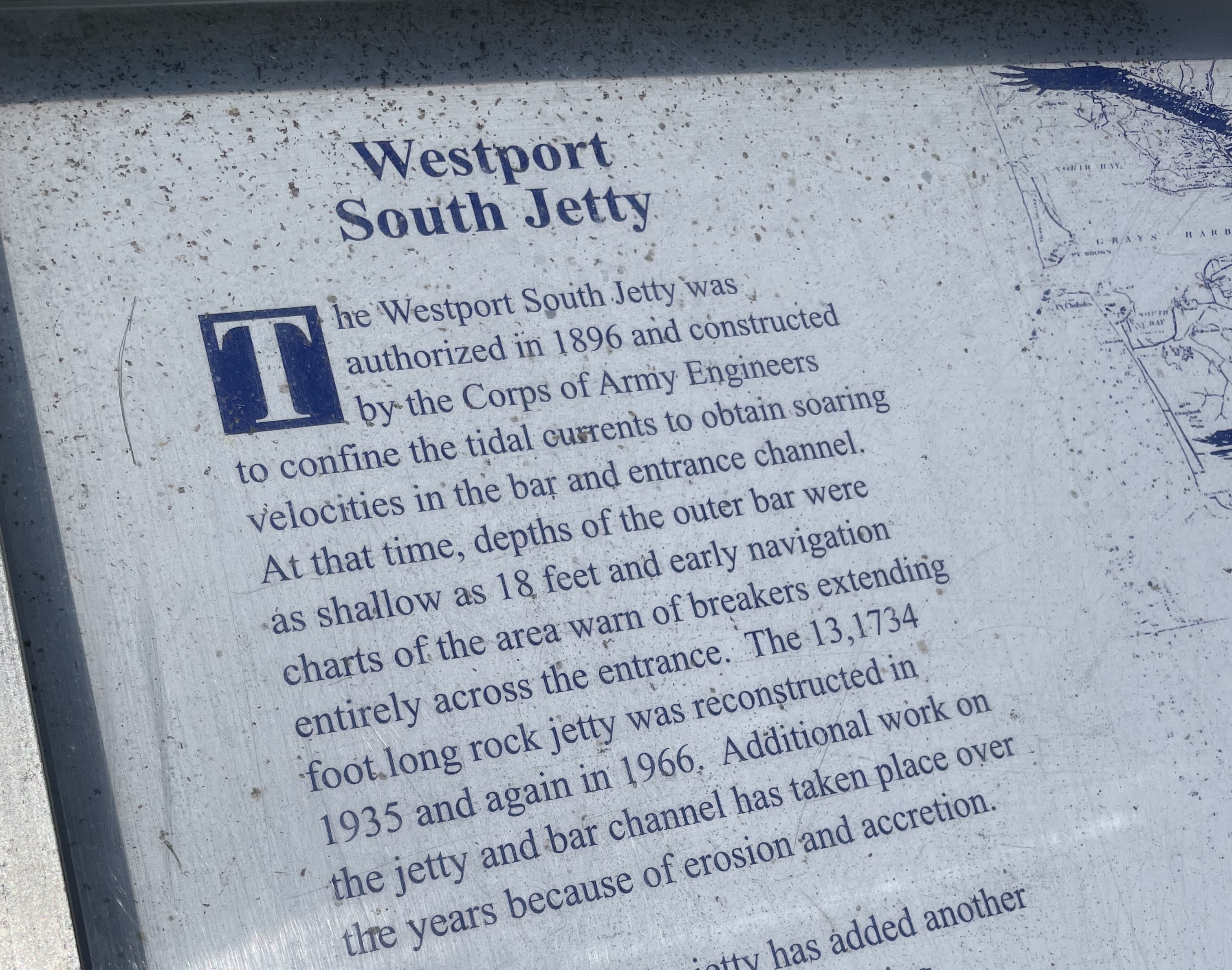 Above: Posted near the Westport Light Trail, a description of how the jetty on the Westport side has been maintained over the years.
The Westport side is part of the Port of Grays Harbor
The Ocean shores side once had an active marina with a restaurant, cocktail lounge and salmon charter boat outings. The Silver King Motel was there too.
The Ocean Shores side once had a ferry to Westport. People liked it. It was shut down because:
Jetty Adjacent to Damon Point
On the Ocean Shores side, the jetty adjacent to Damon Point appears to be neglected/not maintained over the years. This first got my attention when going down there to walk at Damon Point. The public beach access needs improvement.
This local news article describes “coastal erosion” and “…rising sea levels due to climate change…” as part of the story.
Another local article below, tells us the jetty closest to the Damon Point parking area was installed in 1916.
Question for newspeople: What has been done to maintain it since then?
Part two of two in a series:
Nov 2, 2023 The Daily World
A 100-year old jetty used to protect Ocean Shores. Can new technologies save its south end?
“In 1916, the U.S. Army Corps of Engineers completed the construction of Grays Harbor’s North Jetty, a three mile-long berm of boulders jutting into the Pacific, hugging and holding the entire southern shoreline of Ocean Shores. The body of water now known as Oyhut Bay did not exist.”
Grays Harbor did not encroach inland of the 1916 jetty?
“Today, a large remnant of that jetty, roughly 10,000 feet angling to the northeast from the peninsula’s western hoof to the Damon Point parking lot, lies stranded and submerged in the bay, battered by 100 years of bashing saltwater, waves and, once, the impact of an errant fishing boat.”
Jetty installed 100 years ago. If it was important then, why not now?
What was done to maintain this jetty over the past 100 years?
Any questions from newspeople?
Man made structures/one or more jetties installed at the entrance to Grays Harbor have altered the natural migration of sand, not coastal erosion/climate crisis/sea level rise?
“The erosion that you see in Oyhut Bay, and basically the development and expansion of the bay, is part of a very long-term process of the inlet entrance evolving in response to the construction of jetties,” said George Kaminsky, a coastal erosion expert with the Washington state Department of Ecology.
“Another important partner, Martin said, will be the Quinault Indian Nation, which owns the Quinault Marina and RV Park on the east side of the bay.”
“Are we dealing with a natural process? Are we dealing with a partly man made process? Or a combination of both?”
The article above has some excellent images, showing the original jetty and what has changed since the first image was taken in 1942.
Late 2023 – Reaction Mode
Dec 8, 2023 The Daily World
Sacrificial sand: Berm to hold off waves in Ocean Shores, for now
City starts work on emergency erosion solution to protect infrastructure on southern shoreline
By Clayton Franke
“…action to stop, or at least slow, the waves that have washed away 3,000 feet of beach in the last four decades, scouring what’s now known as Oyhut Bay.”
“Located about a half mile west of the Damon Point trailhead, the sand is piled on the pale dune grasses just above the sandy beach.”
Random thoughts and questions:
This is an emergency and the waves washed away 3,000 feet of beach in the last four decades?
What was done to maintain the original (now offshore) jetty?
US federal government is OK with doing maintenance in other areas:
Damon Point Beach Access
Beach access for people on foot cries out for improvement at Damon Point. If the city won’t improve it, maybe the tribe could charge a day use fee and let people walk across a safe path on their land to get to the beach?
For years, we would visit a beach 12 miles west of Port Angeles, just to spend the day. This was part of a private campground. They would charge a few dollars and give you a wristband to spend the day out there. Fantastic location.
More here:
What would Westport look like?
Related:
Ferry to Westport – Fell Apart on the Ocean Shores Side:
Damon Point – Coastal Erosion Attitudes
Less Than Two Miles As The Crow Flies – Ocean Shores Marina History
Ocean Shores Marina History – A Time Gone By
98569 Coastal Erosion Attitudes
Federal Cash For The Coast – 98569
 Westport
When the time is right, the top of Mount Rainier is visible from this cam:
Westport – coastal weather cam here.
Another live cam, just to the south:
 A sunny Friday
Click image once or twice to show detail.
When the time is right, the top of Mount Rainier is visible from this cam:
Westport – coastal weather cam here.
Another live cam, just to the south:
 When the time is right, the top of Mount Rainier is visible from this cam:
Westport – coastal weather cam here.
Another live cam, just to the south:
Westport
When the time is right, the top of Mount Rainier is visible from this cam:
Westport – coastal weather cam here.
Another live cam, just to the south:
 Out to Westport.
Click image once or twice to show detail.
When the time is right, the top of Mount Rainier is visible from this cam:
Westport – coastal weather cam here.
Another live cam, just to the south:

 We took the tour and walked to the top today. Really enjoyed it and would recommend a visit.
What is it called?
Or, Westport Light:
This excellent history page calls it Grays Harbor Light and Grays Harbor Lighthouse.
We used the parking area beyond the state parks sign above and walked on the paved Westport Light Trail to get to the tallest lighthouse in Washington. Weather was fantastic. Great outing.

 Westport
A very nice image identifying local coastal features.
Source/credit: City of Westport
 We used the parking area in the middle of The Cove, then headed out for a nice walk.
Big driftwood, as you arrive at the beach:

 We started by walking towards The Groins. Olympic Mountains in view:


 Waking back towards The Jetty


Several sites on the web offer info on ship locations.
Ship above is DREAM SKY
We continued walking over to the beach south of The Jetty.


 Big driftwood
 A lot of beach out there


 We turned back and walked to our parking spot on the paved Westport Light Trail.
Another chance to get back to the beach:
 Past outings:
When the time is right, the top of Mount Rainier is visible from this cam:
Westport – coastal weather cam here.
Another live cam, just to the south:
 Westport
 Click image once or twice to show detail.
Several sites on the web offer info on ship locations.
Ship above is DREAM SKY
When the time is right, the top of Mount Rainier is visible from this cam:
Westport – coastal weather cam here.
Another live cam, just to the south:


