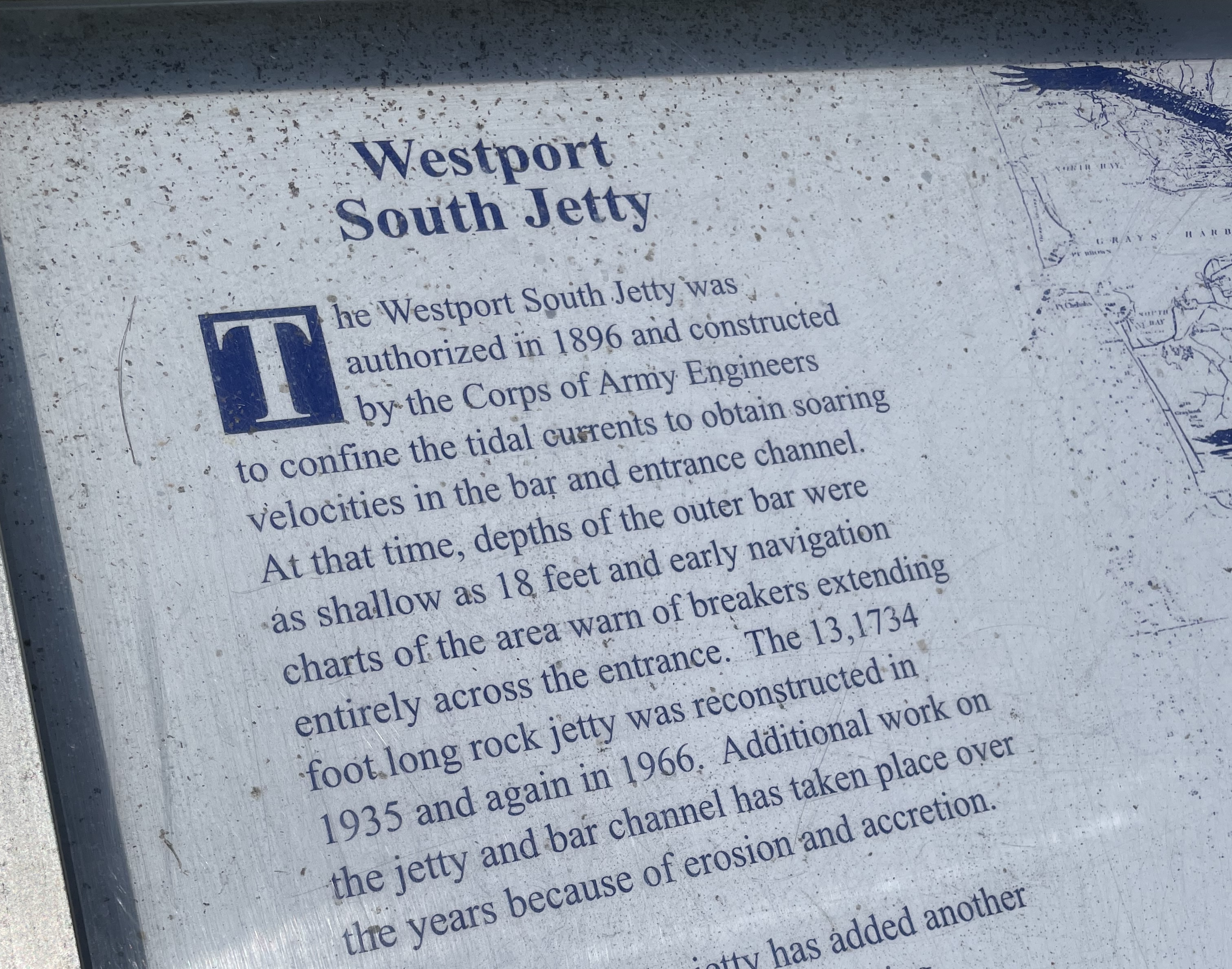
 Above: Posted near the Westport Light Trail, a description of how the jetty on the Westport side has been maintained over the years.
The Westport side is part of the Port of Grays Harbor
The Ocean shores side once had an active marina with a restaurant, cocktail lounge and salmon charter boat outings. The Silver King Motel was there too.
The Ocean Shores side once had a ferry to Westport. People liked it. It was shut down because:
Jetty Adjacent to Damon Point
On the Ocean Shores side, the jetty adjacent to Damon Point appears to be neglected/not maintained over the years. This first got my attention when going down there to walk at Damon Point. The public beach access needs improvement.
This local news article describes “coastal erosion” and “…rising sea levels due to climate change…” as part of the story.
Another local article below, tells us the jetty closest to the Damon Point parking area was installed in 1916.
Question for newspeople: What has been done to maintain it since then?
Part two of two in a series:
Nov 2, 2023 The Daily World
A 100-year old jetty used to protect Ocean Shores. Can new technologies save its south end?
“In 1916, the U.S. Army Corps of Engineers completed the construction of Grays Harbor’s North Jetty, a three mile-long berm of boulders jutting into the Pacific, hugging and holding the entire southern shoreline of Ocean Shores. The body of water now known as Oyhut Bay did not exist.”
Grays Harbor did not encroach inland of the 1916 jetty?
“Today, a large remnant of that jetty, roughly 10,000 feet angling to the northeast from the peninsula’s western hoof to the Damon Point parking lot, lies stranded and submerged in the bay, battered by 100 years of bashing saltwater, waves and, once, the impact of an errant fishing boat.”
Jetty installed 100 years ago. If it was important then, why not now?
What was done to maintain this jetty over the past 100 years?
Any questions from newspeople?
Man made structures/one or more jetties installed at the entrance to Grays Harbor have altered the natural migration of sand, not coastal erosion/climate crisis/sea level rise?
“The erosion that you see in Oyhut Bay, and basically the development and expansion of the bay, is part of a very long-term process of the inlet entrance evolving in response to the construction of jetties,” said George Kaminsky, a coastal erosion expert with the Washington state Department of Ecology.
“Another important partner, Martin said, will be the Quinault Indian Nation, which owns the Quinault Marina and RV Park on the east side of the bay.”
“Are we dealing with a natural process? Are we dealing with a partly man made process? Or a combination of both?”
The article above has some excellent images, showing the original jetty and what has changed since the first image was taken in 1942.
Late 2023 – Reaction Mode
Dec 8, 2023 The Daily World
Sacrificial sand: Berm to hold off waves in Ocean Shores, for now
City starts work on emergency erosion solution to protect infrastructure on southern shoreline
By Clayton Franke
“…action to stop, or at least slow, the waves that have washed away 3,000 feet of beach in the last four decades, scouring what’s now known as Oyhut Bay.”
“Located about a half mile west of the Damon Point trailhead, the sand is piled on the pale dune grasses just above the sandy beach.”
Random thoughts and questions:
This is an emergency and the waves washed away 3,000 feet of beach in the last four decades?
What was done to maintain the original (now offshore) jetty?
US federal government is OK with doing maintenance in other areas:
Damon Point Beach Access
Beach access for people on foot cries out for improvement at Damon Point. If the city won’t improve it, maybe the tribe could charge a day use fee and let people walk across a safe path on their land to get to the beach?
For years, we would visit a beach 12 miles west of Port Angeles, just to spend the day. This was part of a private campground. They would charge a few dollars and give you a wristband to spend the day out there. Fantastic location.
More here:
What would Westport look like?
Related:
Ferry to Westport – Fell Apart on the Ocean Shores Side:
Damon Point – Coastal Erosion Attitudes
Less Than Two Miles As The Crow Flies – Ocean Shores Marina History
Ocean Shores Marina History – A Time Gone By
98569 Coastal Erosion Attitudes
Federal Cash For The Coast – 98569